Many people ask, why don’t planes fly over the Pacific? Actually, some do but the reason many do not may surprise you.
In this post, you will find out that transpacific aviation is not quite as simple as it may seem as we explore the fascinating phenomenon of great circle routes – the shortest paths between two points on the Earth’s surface – and how they shape the way aircraft traverse the Pacific.
If you looked at a map of the world then it would seem to make sense for airlines to fly directly across the Pacific Ocean as that would logically seem to be the shortest route so why do they not do this? I will explain fully below.
Do Planes Fly Over The Pacific Ocean?: Planes actually do fly over the Pacific Ocean. The Pacific Ocean is a major international air route connecting countries in Asia, North America, and Oceania. Many long-haul transpacific routes traverse this ocean. However, in some cases, planes don’t fly over the Pacific Ocean due to the Great Circle routes that follow the shortest distance between two points on a globe.
Contents
Why Planes Don’t Fly Over the Pacific Ocean?
Well, actually some flights do fly over the Pacific. For example, it would be quite difficult to fly to Hawaii without flying over the Pacific. The same goes for flights to other South Pacific islands of course.
However, many direct flights from the US to Eastern Asia and vice versa do not but that is actually due to it not being the quickest and most direct route.
I will explain why now – please bear with me.
Maps
The world map below, that we are all familiar with, is not accurate in terms of layout or distances. It is a representation of a spherical globe on a 2-dimensional map.
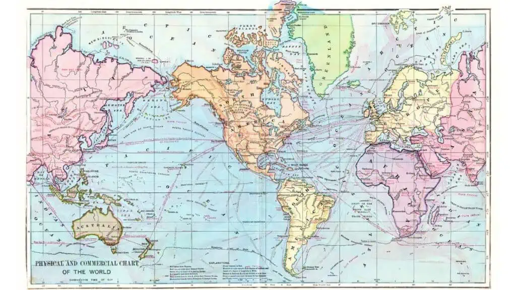
A map projection is a mathematical transformation that systematically converts the Earth’s latitude and longitude coordinates into corresponding points on the map.
There are many different types of projections, each with its own strengths and weaknesses, depending on the purpose of the map.
One common projection is the Mercator projection, which is a cylindrical projection that was developed in 1569 by Flemish cartographer Gerardus Mercator. In the Mercator projection, the Earth’s surface is projected onto a cylinder wrapped around the globe, with the cylinder touching the equator. The cylinder is then “unrolled” to create a flat map.
The Mercator projection has some distinct advantages, such as preserving angles, which makes it useful for navigation purposes. However, it also has some significant drawbacks.
One of the main issues with the Mercator projection is the distortion of areas, especially near the poles. This distortion causes landmasses at high latitudes to appear much larger than they actually are relative to those near the equator.
Why Do Planes Fly in An Arc?
Airlines do prefer to fly over what appear to be curved routes when shown on a map such as the one above. These are called great circle routes which are actually straight when mapped on a globe, instead of a straight route which would actually be a greater distance if you plotted it on a globe.
When an airplane makes the flight from the United States to Japan the flight plan will see it fly in what appears to be a curved route that heads north close to Alaska. This route maximizes the amount of fuel saving and is the shortest route without the need for flying directly across the ocean.
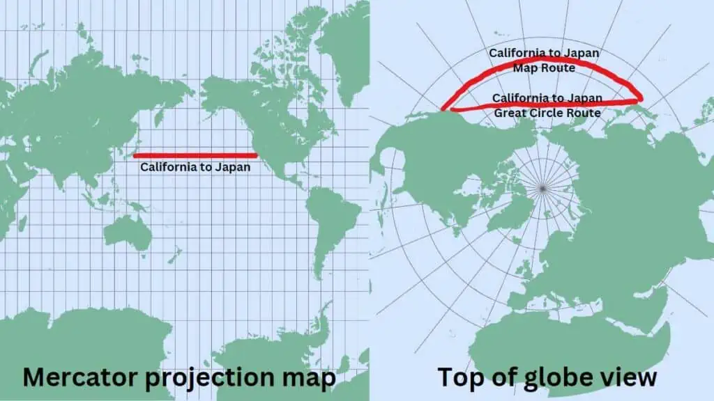
In the two maps above you can see that in the normal map (Mercator Projection) the shortest flight path from California to Japan appears to be straight across the Pacific Ocean. But as the Earth is a sphere and not flat the shortest route is actually going north towards the top of the Pacific.
So when flying from California to Japan, the quickest route is the great circle route because it is the shortest path between two points on the Earth’s surface.
The Earth is a sphere, so the shortest distance between two points isn’t a straight line on a flat map, but rather a curve that follows the Earth’s curvature. The great circle route takes this into account, making the trip quicker and more efficient.
Time And Cost Saving
Taking the shortest paths around the globe, known as Great Circle routes, helps cut down flight costs. This means cheaper tickets for passengers, more affordable air travel, and less fuel used, which is good for the environment. Plus, flights are faster, benefiting both passengers and airlines.
In simpler terms, for airlines in Eastern Asia and the Americas, it’s more practical to fly around the Pacific Ocean instead of across it.
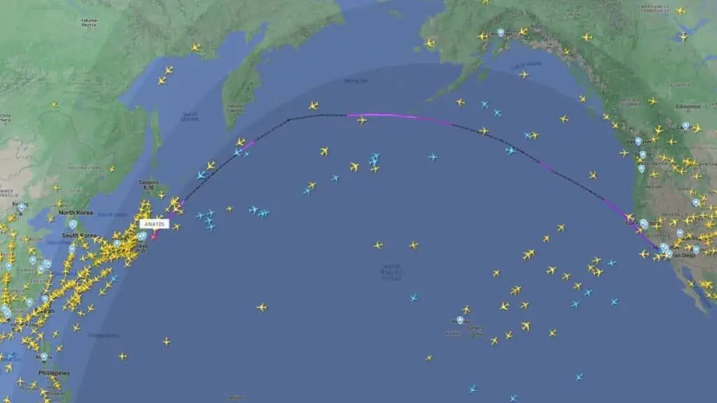
The map below is a screenshot from flightradar24.com showing all of the aircraft over and around the Pacific (at 03:00PST on 4/25/2023). As you can see there are actually plenty of aircraft over the Pacific. The flight highlighted is an ANA flight from Los Angeles to Tokyo, clearly showing the apparent curved route.
Safety
Many people believe that flights do not generally fly over the Pacific due to safety concerns. Although that was true to some extent in the early years of transpacific flying, that is not the reason now. As I have already explained, they fly the Great Circle route which is shorter.
However, as the Great Circle route does tend to eliminate the need for flying for many hours over the ocean it does have one safety advantage.
When flying closer to land, an alternate airport would be closer to divert to in case of an emergency than say from the middle of the Pacific.
Weather Patterns
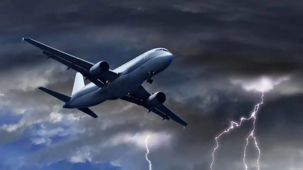
Another advantage of flying the Great Circle routes is the inconsistent weather that sits above the Pacific Ocean. Storms are far more frequent over oceans than on land and due to this airlines will look to minimize the time spent flying over the ocean.
The Pacific Ocean in particular has some of the most turbulent weather on the planet due to the ocean being the origin site of many thunderstorms and cyclones this obviously makes it an incredibly dangerous place to be flying an airplane.
This is why airlines, specifically ones in and around the Pacific, may fly around neighboring countries to avoid the ocean due to the weather likely being much calmer.

The Jet Streams
Jet Streams are air currents that can circle the planet for miles above the surface and is also another reason why planes do not make journeys across the Pacific Ocean.
Flying in a jet stream can save time and fuel for the aircraft as the plane is being pushed along in the current and thus can pull the pack on the throttle and save fuel.
Flying against a jet stream can cause the aircraft to suffer turbulence and it can damage the plane.
There is the Polar Stream which heads over Canada and Alaska making it a far faster route for flights in the region to fly this route than over the Pacific where there are no jet streams.
How Long Does It Take To Fly Over The Pacific Ocean?
The time it would take to fully cross the Pacific Ocean relies on a few factors which are: the aircraft making the journey, the origin point, the destination, weather conditions, and the fuel efficiency.
A Boeing 747 can make the journey from Los Angeles to Tokyo in around 11 to 12 hours on average but the time would massively vary depending on the weather conditions or the distance between the start and end point.
Smaller aircraft would also obviously take longer to cross the ocean as they would be needing to refuel anywhere they can.

Final Thoughts

I have been traveling around the world by air since the early 70s and living overseas too. I worked for British Airways for a number of years and I am also a private pilot. About Me

